Welcome to dinosauria.ucoz.com!
Here you will find the information on dinosaurs and other reptiles! The registered user will get access to scientific publications (section "Files Archive")!
Main » 2008»July»17 » THREE-DIMENSIONAL MODELLING AND ANALYSIS OF DINOSAUR TRACKWAYS
THREE-DIMENSIONAL MODELLING AND ANALYSIS OF DINOSAUR TRACKWAYS
06:09
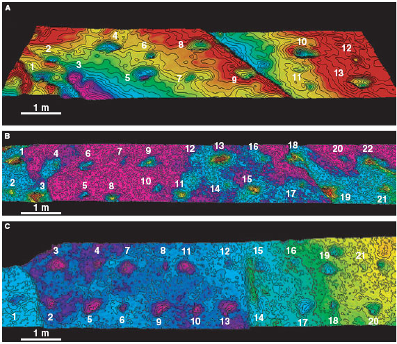
Light Detection And Range (LiDAR) imaging provides a means to model the 3D geometry of fossil tracks in the field with high accuracy. This represents a considerable advance for the science of vertebrate ichnology in which traditional field methods suffer from a significant degree of abstraction and lack the resolution required to interpret tracks quantitatively. Three-dimensional LiDAR models provide additional morphometric information and allow the application of new analytical tools unique to the digital environment. The method will enable fossil track morphometrics to develop into an iterative process that combines 3D visualization and multivariate statistical methods, blending qualitative and quantitative approaches and allowing track morphologies to be compared holistically. Modelling of trackways from Fumanya (south-east Pyrenees) using LiDAR has enabled variation in linear track dimensions to be explained by the varied contribution of different modes of shear with increasing depth below the foot ⁄ sediment interface. Features in the relief of pes traces indicate that subsurface zones within their track volumes are defined by the interaction of puncture and local shear, below a surface zone of liquefaction failure now lost to erosion. This model of mechanical failure enables a preliminary review of the pedal kinematics of titanosaurid sauropod dinosaurs and suggests multiphase loading of the sediment by the titanosaurid pes. However, from inspection of these 3D surfaces alone it is not possible to differentiate between the possibility of one or two discrete phases of pedal motion preceding the toe-off event at the maximum height of the support phase. By integrating LiDAR models with analogue modelling within a 3D digital environment it will be possible to clarify such interpretations of fossil tracks and the locomotor mechanics of extinct animals.
A–C, 3D LiDAR models of the succession of tracks making up the trackways (A) 1, (B) 2 and (C) 3 from the Fumanya South locality. Each model is composed of a contoured and colour-coded surface produced through dense point cloud data.